OGC API Features is a modern, RESTful standard developed by the Open Geospatial Consortium (OGC) for accessing and managing geospatial feature data over the web. It is the evolution of WFS (Web Feature Service) and unlike its predecessor, which relied heavily on XML and complex service operations, this API uses simpler HTTP methods and JSON to provide a more accessible and efficient interface.
Available for AutoCAD, BricsCAD, ZWCAD, GstarCAD and Desktop
Spatial Manager products include a native provider for download and import WFS and OGC API Features geometries and data to DWG or DXF, and also convert them to other formats like SHP, KML, GML or GeoJSON.
In this tutorial, we use OGC API Feature services from the Netherlands’ public data, published by PDOK (Publieke Dienstverlening Op de Kaart).
Follow these simple steps for importing WFS/OGC API Features data to DWG or DXF:
1. Locate your working area
- If you already have an existing drawing, execute SPMSETCRS command and select the coordinate reference system proper to your area.
- If you want to start from an empty drawing, you could execute SPMBGMAPSHOW command, enable any background map and navigate to the desired zone.
2. Create data source
- From the Spatial Manager palette (SPM command) create a new User Data Source.
- Select WFS / OCG API - Features as provider.
- Set the URL of the service end point (in this tutorial we use https://api.pdok.nl/lv/bgt/ogc/v1).
- Finish the data source wizard.
3. Import data
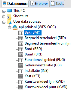
- Expand the created user data source.
- Select the desired table and import it.
- It is recommended to select Import only Features in the current view to speed up the process.
- Repeat if you need to import more tables.
4. Review data
- In addition to the geometries, attribute data is also attached. Review it from the palette (SPM command) or data grid (SPMDATATABLEGRID command).
Convert and export to other formats
- Additionally, you can convert to other GIS formats using SPMEXPORT command, directly from the contextual menu from the palette or using Spatial Manager Desktop standalone application.
The evolution of the Web Feature Service (WFS) versions can be summarized as follows, all of them are compatible with Spatial Manager products.:
-
WFS 1.0: One of the earliest implementations, this version laid the groundwork by defining the basic operations for querying geospatial feature data. It set the stage for standardized geospatial data exchange.
-
WFS 1.1: This version introduced improvements in query capabilities, including enhancements for spatial and attribute filtering, as well as better support for more complex feature geometries.
-
WFS 2.0: Representing a further leap forward, WFS 2.0 improved interoperability, increased flexibility, and refined transaction capabilities, making it more robust for a variety of geospatial data services.
-
OGC API Features (initially known as WFS 3.0): This rebranding was important not just in name but in its architectural approach, marking a decisive move away from an XML/SOAP-based framework to a more straightforward JSON/HTTP-centric model.
Note: Some functionalities can be found in the Standard or Professional editions only


