Spatial Manager Blog : Layers (page 2)

Data sources smart search
When working with external Layers, which are loaded into a Map by reading spatial data sources, one of the usual problems is the modification (change of name, change of location, etc.) of these data sources Spatial Manager Desktop™ includes a... more
Projecting Maps on the fly
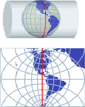
Spatial Manager Desktop™ considers the coordinate systems of the Layers in a Map to get a real view of their Features which will be projected according to the coordinate system of the MapWhen working with an application that includes... more

Editing ‘Non editable’ Layers
‘Non editable’ Layers are those that are connected to any data source through a ‘read only’ data Provider The reason why these layers are deemed ‘non-editable’ is that, since the data sources connected can not be saved if their content in a... more
Tags
2D
3D
ASCII
Alphanumeric data
Background Maps
Batch processing
Bing
Blocks
CRS
CSV
Calculator
Capture
Centroids
Channels
Compare
Configuration
Contours
Copy and paste
Corporate
DXF
Data Grid
Data conversion
Data loading
Data management
Data sources
Data table
Disconnect
Dissolve
Downloads
Drafting
Drone
Edition
Elevations
Esri
Excel
Export
FDO
Fills
GML
GPS
Geo-coding
Geo-reference
GeoJSON
GeoPackage
Geometry
Google Earth (KML/KMZ)
Google Maps
IGN
Import
LINZ
Labels
Layers
LiDAR
Map Books
Mapbox
Maps
ODBC
OGC
OpenStreetMap
Ordnance Survey
Overlays
PDF
PDOK
Partners
PostGIS
Preview
Price list
Print
Print and Plot
Properties
Providers
Queries and Filters
Raster
Release
Rubber sheet
SQL Spatial
Selection
Shapefiles (SHP)
Share
Spatial analysis
Spatial queries
Street View
Styles
Terrains
Thematics
Tricks and Tools
WFS
WMS
WMTS
Yandex