Spatial Manager Blog : Geo-reference (page 2)

Geo-referencing captured images from Maps
Capturing raster images from Dynamic Background Maps in ‘Spatial Manager’ (CAD editions) allows you to generate static images (snapshots) from the current Map view. In the latest application update (v.4.2), this function has been improved in two ways... more
V3: Amazing Background Maps in AutoCAD and BricsCAD
The users of AutoCAD (v.2008 and later) or BricsCAD (v.13 and later) will greatly improve their drawings with the amazing “Background Maps” of Spatial Manager™ Choose from among many “Backgrounds Maps” from many providers such as OpenStreetMap, Bing, MapBox, Esri,... more

Base maps as Map backgrounds
Using base maps (roads, aerial, etc.) from imagery providers allows, not only the composition of more attractive Maps in mapping applications, but also the use of these base images as a practical reference system or a powerful tool for checking on the... more
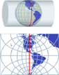
Projecting Maps on the fly
Spatial Manager Desktop™ considers the coordinate systems of the Layers in a Map to get a real view of their Features which will be projected according to the coordinate system of the MapWhen working with an application that includes... more

How to geo-reference an ‘unreferenced’ spatial Table?
Occasionally you will find some spatial data (SHP files or PostGIS tables, for example) that does not include geo-referencing information, but you know the Coordinate System (CRS) used to define the Features in the Table If this applies to you,... more