Inside one of the main ‘Spatial Manager’ functionalities, the ability to import features from tens of cartographic and GIS file formats and databases into your drawings (AutoCAD, BricsCAD or ZWCAD), you can find the option to label the objects as they are imported, by getting the label from any of the attached object data. In the latest application versions a couple of interesting new options have been included
Related videos: AutoCAD / BricsCAD / ZWCAD
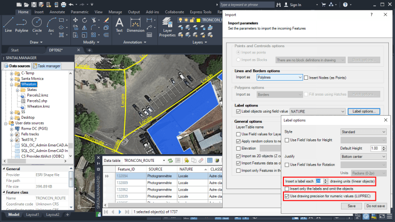
Object labeling options can be found in the intuitive Import Wizard and allow you to define the labels style, accuracy, and arrangement. In the following image you can find the label options window in which the two new ones we reviewed in this post have been highlighted
Firstly, it is now possible to define the numerical precision of labels coming from numerical fields according to the linear precision value defined in the base CAD application, i.e. the CAD system variable LUPREC. This allows to uniformize the number of the decimal places for all the labels coming from the same numerical field, regardless of the number of the decimal places in the associated data table, which in many occasions can be different for each value
Note: The same option can be found when using Attribute Blocks while importing point objects and Attribute data is taken from numeric fields
Secondly, it is now possible to define the spacing between repetitive labels that are placed along of any linear object segment (road, supply network, etc.). The gap is defined by the distance between labels in drawing units. This allows you to control the labeling density for this type of objects so that they can be comfortably read in the drawing
Enjoy the above videos, which show how the new labeling options work
Learn more about importing and labeling objects in the ‘Spatial Manager’ technical Wiki:


