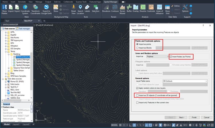
Spatial Manager (CAD versions) includes the option to Insert Nodes when importing objects such as Polylines or Polygons. These nodes can be created as Points or as Block Inserts (if any have been defined) in the drawing. This functionality extends the import possibilities since in many cases, as in the example shown here, it is necessary to use this type of geometries in order to carry out subsequent operations or analysis
Related videos: AutoCAD / BricsCAD / ZWCAD / GstarCAD
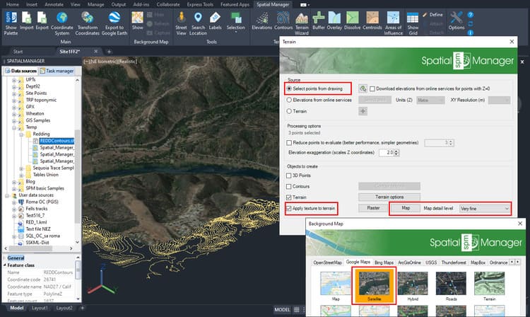
Although there are many other examples of application of this option to generate 3D Points, in this case we are importing a 3D Contours (located at its elevation) Shapefile. Then we are going to run the application’s Terrain wizard in order to generate a 3D Terrain, which requires us to either select Points from the drawing, or obtain them through an online service
In the Contours import process, we select the options highlighted in the above image. Once imported and inserted the nodes in each vertex of the Contours (3D Points in this case), we will delete the contours Polylines to keep only the 3D Points (this is not necessary, but we do it to improve the clarity of the example)
As you can see in this image, to generate the 3D Terrain from the Points we have collected, we will select them in the Terrain wizard. In this example, we also project the image of a selected online Map on the 3D Terrain object (in the CAD applications where this option is available)
Enjoy the videos
Learn more about Importing options in the ‘Spatial Manager’ technical Wiki:


