Spatial Manager Blog : Desktop L2 (Medium) (page 9)
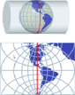
Projecting Maps on the fly
Spatial Manager Desktop™ considers the coordinate systems of the Layers in a Map to get a real view of their Features which will be projected according to the coordinate system of the MapWhen working with an application that includes... more

How to access ODBC connections
The connections through the Windows ODBC standard (Open Database Connectivity) expand the possibilities of access to data sources based on basic connection drivers that the operating system itself or some other applications can provide Access to certain file types, or... more

Export alphanumeric data from spatial tables
Spatial Manager Desktop™ has many tools to exploit the information included in spatial Tables. One of these tools is the “Export data” function, which you can use to export the alphanumeric data in the Data gridBy exporting the alphanumeric... more
Import directly to PostGIS databases
Many Spatial Manager Desktop™ users are familiar with the large number of options included in the application to export spatial data, but few users are aware of the possibility to directly Import Tables to a container, such as a Schema of a... more

Create 3D Buildings in Google Earth from SHP files
The KML or KMZ files of Google Earth can include some little-known parameters which apply to the Features they contain. One of these parameters is the Altitude of the Features By using the Altitude parameter, the Features can be placed... more

Applications configuration files and backup copy
All the settings for the Spatial Manager™ applications are stored in XML files and a backup copy is automatically created whenever any of them is modified This is the list of configuration files for Spatial Manager: · Shortcuts.config: Shortcuts configuration... more