The new autumn version ‘Spatial Manager v5’ has been released today. You’ll find great improvements in data management, especially in CAD applications (AutoCAD, BricsCAD and ZWCAD) which have incorporated a powerful and unique Data Grid (already in Desktop) that will allow you to manage the spatial data in your drawings and maps more effectively than ever
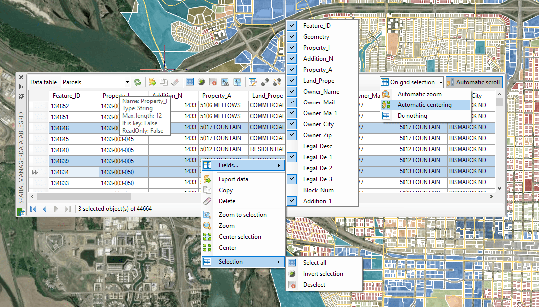
The ‘Spatial Manager 5’ Data Grid
-
New command ‘SPMDATATABLEGRID’: The Data Grid Palette
- Interactive and synchronized
- Selecting objects and navigation tools in the grid
- Editing data and columns
- Columns sorting
- Sorting data by column
- Automatic column width adjustment
- Direct export to CSV, TXT, etc.
- Multi-table grid
- Video: AutoCAD * BricsCAD * ZWCAD
- Related Blog post
- Learn more: AutoCAD * BricsCAD * ZWCAD
- Recovering data Table structures from the drawing objects
- Choose the value of a Field from a list of available values when selecting by query
- Import and export user dynamic Background Maps
- AutoCAD 2019, BricsCAD 19 and ZWCAD 2019 compatible
-
Other improvements
- Rename data Tables
- Object data (EED) are no longer attached to the texts when labeling while importing
- “Text qualifier” setting in the ASCII data provider when Importing and Exporting
- Data character encoding setup when exporting to Shapefiles (SHP)
- Spatial filters in the WFS (OGR) data provider
- EPSG tables updated to version 9.5 (CRSs and other objects)
- Applications performance when reading the object data has been greatly improved
- Now you can also export 2D Polylines and 3D Polylines Length
- … and more
Note: Certain functions are available on the “Standard” and/or “Professional” editions only, and some of them may refer only to CAD versions
Related links:
- Application V5 Changelogs
- Product pages
- Product Downloads
- Editions and prices
- User Guides, Help and Technical docs


