Blog : CRS

Many ‘Spatial Manager’ functions (Import, Export, Background Maps, etc.) can automatically perform a process of coordinates Transformation from the source to the target as part of the sequence executed by these functions. That means that the application will calculate a... more

The functionality of transforming the coordinate system (CRS) of a drawing in ONE STEP is one of the tools most requested by the application users. This operation, which in some cases presents a high geometric complexity, is totally transparent and... more

An application whose primary focus is the spatial information handling (such as ‘Spatial Manager’), must include specific functionalities related to Coordinate Reference Systems (CRSs) and Transformations of geographic data (vector or raster) between different CRSs ... more
Over the last few days a large number of Coordinate Systems used in Western Australia have been added to the ‘Spatial Manager’ geographic databases, along with all the required geographical projections and conversion process parameters
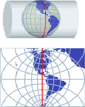
Spatial Manager Desktop™ considers the coordinate systems of the Layers in a Map to get a real view of their Features which will be projected according to the coordinate system of the MapWhen working with an application that includes... more

Occasionally you will find some spatial data (SHP files or PostGIS tables, for example) that does not include geo-referencing information, but you know the Coordinate System (CRS) used to define the Features in the Table If this applies to you,... more