Raster geo-referenced image files are widely used by anyone working in GIS or Mapping environments because they can include orthophotos, scanned geographic areas or details, information overlays, etc. Although almost all CAD applications have tools for attaching raster images in your cartographic drawings, ‘Spatial Manager for AutoCAD/BricsCAD/ZWCAD’ adds significant functionality to all of them
Related videos: AutoCAD / BricsCAD / ZWCAD
‘Spatial Manager’ – Importing geo-referenced images
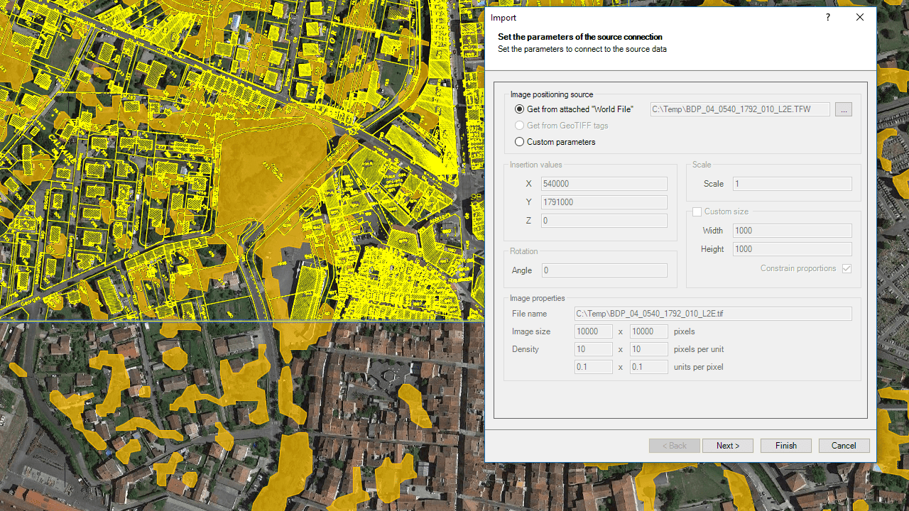
You can attach raster images to your drawings through the ‘Spatial Manager’ Import function (from the contextual menus in the main application palette, or by using SPMIMPORT), since a specific data provider is included for these files (TIF, PNG, JPG, JPEG, TIFF)
The geographic location of the image will be automatically retrieved from the associated “World file“ or from the tags included in the image file itself in the case of GeoTIFF files. In addition, the parameter window of the data provider also allows you to enter or modify the image insertion data: coordinates, scale (or global dimensions) and rotation angle
As with any other application data provider, you can define a transformation of coordinates when importing, resulting in a new raster image on which the distortions required by such transformation will be applied. Noting that this data provider is also compatible with the powerful ‘Import-all’ function, which allows you to process batch importing of any spatial data files set, we can consider that ‘Spatial Manager’ is the perfect complement to handle spatial raster data within any CAD application (see the table below)
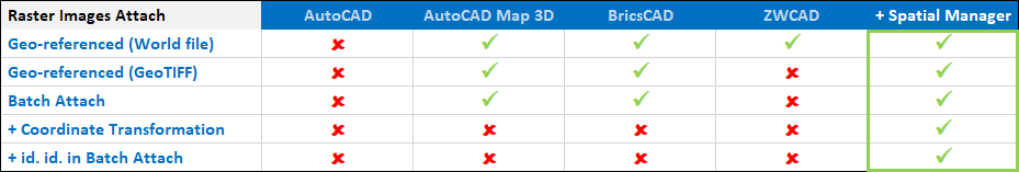
Comparative table – CAD solutions plus ‘Spatial Manager’ application (Note: ZWCAD does not support either JGW or PGW World files, only TFW or J2W)
You can explore the capabilities provided by this functionality in addition to the ability to Publish raster images in Google Earth or Capturing geo-referenced snapshots from the dynamic Background Maps
Note: The Rater Image provider is available in the ‘Standard’ or ‘Professional’ editions only
Learn more about Importing from a wide range of spatial data sources into your drawings:
Take a look at all the news and improvements in ‘Spatial Manager 4.2’


