Background maps

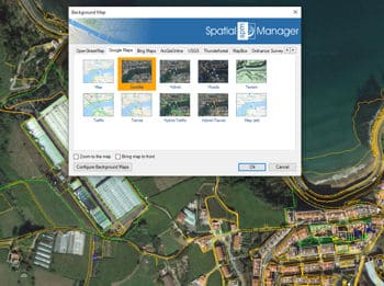
Choose from among a lot of dynamic Backgrounds Maps from providers such as Google Maps, OpenStreetMap, Bing, MapBox, Ordnance Survey, etc., or configure your own maps from TMS, WMS or WMTS servers

Spatial Manager Desktop™ allows to the users choose from among a lot of dynamic Backgrounds Maps from many providers such as Google Maps, OpenStreetMap, Bing, MapBox, Ordnance Survey, etc., or customized maps from TMS, WMS or WMTS servers. These maps will enhance your documents quality and will let the users compare and check better

The map images are automatically updated when the document view changes (zoom, pan, etc.) and the images resolution is automatically adapted to the view size. The user can export/import customized map definitions to be shared with other users

Background base maps (roads, satellite, hybrid)

Quickly change the maps background by choosing between solid colors or geo-referenced high quality imagery as base maps

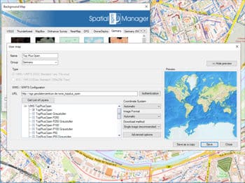
User Maps

Configure new Groups and new Maps by entering a minimum of data. There are also tools to edit the Maps configuration data or delete them from the list
frequently asked questions

  • Windows 11, Windows 10, Windows 8.1, Windows 8, Windows 7 SP1, Windows Vista SP2, Windows Server 2008 SP2 and higher
  • 1024 x 768 VGA graphics, or higher
  • 1 GHZ 32-bit or 64-bit processor, or faster
  • 1 GB RAM or more (4GB recommended)
  • 2 GB free disk space, or more
  • Microsoft .NET 4.5 (installer included)
  • Windows Installer 3.1 or later
Spatial files
  • Esri Shape file - (SHP)
  • Google Earth file - (KML, KMZ)
  • OpenStreetMap file - (OSM, PBF, OSC) (1)
  • LiDAR file - (LAS, LAZ)
  • GPS exchange format file - (GPX)
  • Esri ASCII Grid file - (ASC, ASCII) (1)
  • ASCII text file - (ASC, CSV, NEZ, TXT, XYZ, UPT)
  • SQLite file - (SQLITE, DB)
  • GeoPackage file - (GPKG) (1)
  • GML file - (GML, GZ, XML)
  • Autodesk SDF file - (SDF) (3)
  • MicroStation v.7 file - (DGN) (2)
  • AutoCAD DXF file - (DXF) (2)
  • Esri ArcInfo export file (ASCII) - (E00) (1) (2)
  • MapInfo file - (TAB) (2)
  • MapInfo interchange format file - (MIF/MID) (2)
  • GeoJSON file - (GEO.JSON)

Spatial raster files
  • Variable resolution Raster image file - (Cloud Optimized GeoTIFF/COG TIFF) (1) (4)

Spatial data servers and Geo-databases
  • Esri Geodatabase File - (GDB) (1)
  • PostGIS database
  • Microsoft SQL Server Spatial database
  • MySQL database (1) (3)

Image map servers
  • WMS Web Map Services (4)
  • WMTS Web Map Tile Services (4)
  • XYZ/TMS Tile Map Services (4)

Other spatial data sources
  • Open Database Connectivity ODBC (1)
  • WFS data store (1)
  • WFS data store (FDO) (1) (3) (5)
  • WFS data store (OGR) (1) (2) (5)

(1) Read-only
(2) OGR data source
(3) FDO provider
(4) Background Maps technology
(5) DEPRECATED - Whenever possible use the native WFS data provider

Note: certain data Providers are only valid for some Editions of the application
  • We process a personalized analysis of each case, so some types of advanced licenses are not offered directly on the web store. Please contact to support@spatialmanager.com indicating your needs and we will send you a customized quote