SPM Desktop > Features > Geometry tools > Geometry editing tools

Geometry editing tools

New in V10

A wide range of functions to edit, reshape, and analyze spatial geometries. Tools such as Convex Hull, Envelope, or Triangulation. Additional capabilities like Simplify reduce complexity in shapes or Vertex extraction are available.

Editions: Professional
What's included in the feature Geometry editing tools

Discover the full potential of this set of tools designed to enhance GIS data integration and editing within .

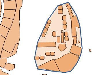
Convex Hull

Generates the smallest convex polygon that completely encloses a selected set of geometries. This operation is useful for creating bounding areas, simplifying complex datasets, and performing spatial analysis. The resulting shape forms the minimal convex envelope around the input features, ensuring optimal coverage with minimal boundary length.


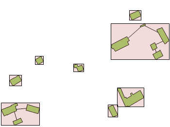
Envelope

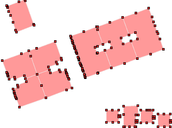
Creates an envelope or bounding box for selected geometries. This refers to the smallest rectangular area that fully contains each object. It is commonly used to generalize shapes, define extents, or prepare spatial data for indexing, visualization, or spatial queries. The result is a simplified and standardized representation of the original geometry's outer limits.


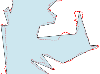
Simplify

Reduces the number of vertices (nodes) to simplify polylines or polygons, optimizing geometry complexity while maintaining overall shape integrity. This function is useful for improving performance and visualization of spatial data by decreasing detail where appropriate. When working with adjacent polygons, caution is advised as simplification may create unintended intersections or holes. The tolerance parameter controls the maximum allowed deviation between the simplified geometry and the original.


Triangulation

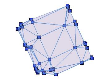
The Triangulation from Points tool generates a mesh of interconnected triangles by connecting a given set of points. This process creates a network of triangles that can be used for surface modeling, terrain analysis, and interpolation of spatial data. The resulting triangular mesh provides a foundation for advanced GIS and CAD operations, ensuring accurate representation of complex spatial structures.
Vertex

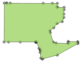
The Vertex Extraction tool generates individual point features from the vertices of existing geometries. This function is useful for analyzing, editing, or exporting key coordinate points that define lines, polylines, or polygons.

frequently asked questions
  • Windows 11, Windows 10, Windows 8.1, Windows 8, Windows 7 SP1, Windows Vista SP2, Windows Server 2008 SP2 and higher
  • 1024 x 768 VGA graphics, or higher
  • 1 GHZ 32-bit or 64-bit processor, or faster
  • 1 GB RAM or more (4GB recommended)
  • 2 GB free disk space, or more
  • Microsoft .NET 4.5 (installer included)
  • Windows Installer 3.1 or later
Spatial files
  • Esri Shape file - (SHP)
  • Google Earth file - (KML, KMZ)
  • OpenStreetMap file - (OSM, PBF, OSC) (1)
  • LiDAR file - (LAS, LAZ)
  • GPS exchange format file - (GPX)
  • Esri ASCII Grid file - (ASC, ASCII) (1)
  • ASCII text file - (ASC, CSV, NEZ, TXT, XYZ, UPT)
  • SQLite file - (SQLITE, DB)
  • GeoPackage file - (GPKG)
  • GML file - (GML, GZ, XML)
  • Autodesk SDF file - (SDF) (3)
  • MicroStation v.7 file - (DGN) (2)
  • AutoCAD DXF file - (DXF) (2)
  • Esri ArcInfo export file (ASCII) - (E00) (1) (2)
  • MapInfo file - (TAB) (2)
  • MapInfo interchange format file - (MIF/MID) (2)
  • GeoJSON file - (GEO.JSON)

Spatial raster files
  • Variable resolution Raster image file - (Cloud Optimized GeoTIFF/COG TIFF) (1) (4)

Spatial data servers and Geo-databases
  • Esri Geodatabase File - (GDB) (1)
  • PostGIS database
  • Microsoft SQL Server Spatial database
  • MySQL database (1) (3)

Image map servers
  • WMS/OGC API Maps Web Map Services (4)
  • WMTS/OGC API Tiles Web Map Tile Services (4)
  • XYZ/TMS Tile Map Services (4)

Other spatial data sources
  • Open Database Connectivity ODBC (1)
  • WFS/OGC API Features data store (1)
  • WFS data store (FDO) (1) (3) (5)
  • WFS data store (OGR) (1) (2) (5)

(1) Read-only
(2) OGR data source
(3) FDO provider
(4) Background Maps technology
(5) DEPRECATED - Whenever possible use the native WFS/OGC API Features data provider

Note: certain data Providers are only valid for some Editions of the application
  • Spatial Manager applications are updated and released every 3 or 4 months